GPTRA Jodie Stavinoha Bridge Total Closure
Fort Bend Grand Parkway Toll Road Authority
Grand Parkway/SH 99 – Total Closure
Jodie Stavinoha Bridge: Riverpark Dr. to New Territory Blvd.
Northbound – October 28 at 7:00 am through November 21 at 5:00 pm
Southbound – Tentatively November 27 at 5:00 am through December 22 at 5:00 pm
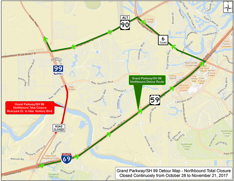
Fort Bend Grand Parkway Toll Road Authority (FBGPTRA) will continue construction on the north bound lanes of the Jodie Stavinoha bridge over the Brazos River located between Riverpark Dr. and New Territory Blvd. The total closure is required to complete the emergency repair that will stabilize the northern bank of the Brazos River and prevent any damage to the Grand Parkway/SH 99 bridge while ensuring the safety of the traveling public. Beginning Saturday, October 28 at 7:00 am, the northbound mainlanes between Riverpark Dr. and New Territory Blvd. will be closed continuously until Tuesday, November 21 at 5:00 am when one lane will reopen. Southbound traffic over the Jodie Stavinhoa Bridge will remain open in one lane only during this time.
Northbound traffic on Grand Parkway/SH 99 may detour by traveling north on IH 69/US 59, turn left to proceed north on SH 6, then turn left to proceed west on US 90A and proceed to Grand Parkway (SH 99). Traffic will be able to reenter the SH 99 mainlanes at the northbound entrance ramp from US 90A/ FM 1464.
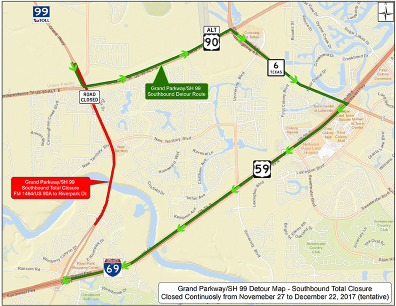
Between November 21 and November 27, both northbound and southbound Grand Parkway/SH 99 traffic is scheduled to remain open in one lane only. On November 27th the southbound mainlanes will be closed continuously until Friday, December 22 at 5:00 pm. All dates on the southbound traffic closure are tentative and subject to change at this time.
Southbound traffic on Grand Parkway/SH 99 will exit FM 1464/US 90A, turn left to proceed east on US 90A, then turn right to proceed south on SH 6. Traffic will be able to access IH 69/US 59 to proceed to their final destination. Local New Territory residents may continue to access New Territory Blvd. and Sandhill Dr. using the SH 99 frontage roads and auxiliary lane.
We advise the traveling public to consider alternative routes during the closure times listed above. Our goal is to minimize traffic delays while ensuring the safety of the traveling public at all times. Please use caution and be aware of your surroundings when navigating through the construction and detour areas. For updates and information, visit our website www.fbctra.com.
Grand Parkway/SH 99 – Jodie Stavinoha Bridge
Total Closure Detour Map
SH 99 Northbound Detour (October 28 – November 21)
SH 99 Southbound Detour (Tentatively: November 27 – December 22)
Southbound New Territory Entrance Ramp
The Southbound New Territory entrance ramp is closed until further notice due to the Jodie Stavinoha Bridge construction and the safety of the traveling public. Therefore, the tolls at the southbound New Territory plaza are waived for the duration of the ramp closure.
Fort Bend County Toll Roads Resume Tolling Monday
FOR IMMEDIATE RELEASE
Fort Bend County, Texas — The Fort Bend County Toll Road Authority ceased all tolling on Sunday, August 27, 2017 in coordination with tolling partners in the Houston area to facilitate easier transportation following the impacts of Hurricane Harvey.
After several days of conversations and discussions we have determined that the resumption of tolling in Fort Bend County will begin on Monday, Sept. 11th for the Fort Bend Parkway from Beltway to south to Sienna Parkway and the Grand Parkway (SH-99) from Westpark south to I-69 (US-59). On Wednesday tolls will resume on the Westpark Tollway from the Fort Bend County line west to SH-99. CORRECTION: all three of Fort Bend County’s toll roads do have non-tolled alternatives.
Harris County Toll Road Authority (HCTRA) may resume tolling soon but they do not have a specific date at this time. For information about the resumption of tolls on HCTRA-managed roadways, see https://www.hctra.org/. TxDOT will also resume tolling soon but could not provide a firm date at the time of writing.
###
Tolls Waived Until Further Notice
Due to Hurricane Harvey, FBCTRA has waived all tolls until further notice; and will provide 24 hour notice prior to resuming tolls.
Current Road Closures
The Jodie Stavinoha Bridge over the Brazos River on Grand Parkway is CLOSED in both directions until further notice.
Tropical Depression Harvey Update
From the Fort Bend Office of Emergency Management
Fort Bend Office of Emergency Management Update – Tropical Depression Harvey
August 23, 2017 Mid-Day – Fort Bend County Toll Road Authority
The Fort Bend County Office of Emergency Management has provided the following update regarding Tropical Depression Harvey.
Fort Bend County Office of Emergency Management (FBC OEM) is monitoring Tropical Depression Harvey in the Gulf. FBC OEM is currently at Level III (Increased Readiness).
Below is a summary from the latest National Weather Service information:
- The remnants of Harvey are now a tropical depression and will most likely soon become a tropical storm
- Harvey is forecast to be a strong tropical storm or weak hurricane
- A Tropical Storm Watch was issued at 10am for several counties, including Fort Bend County
- Harvey is forecast to make landfall on the mid Texas coast on Friday
- There is the potential for the system to slow down after landfall and then move slowly east or northeast – this will impact our area
- The earliest tropical storm force winds will impact our area is Thursday night but it more likely that we will begin experiencing these winds Friday morning
- It is likely that we will experience tropical storm force winds throughout the weekend and into Monday
- It should be noted that tornadoes are possible in the spiral bands mainly on the right side of the track – this includes our area
- With landfall and then a slow track east and/or northeast means we could experience periods of heavy rain Friday through Monday
- NWS thinks that coastal counties will get about 10-15 inches of rain with up to 20 inches of rain possible
- Counties well inland will experience less
- We will most likely begin to see rain from this system Friday afternoon
- Flash flood watches will be likely in our area as we get closer to the event
- It should be noted that there is still uncertainty in the track of the system, which will affect rainfall totals in our area – we hope to have a more refined forecast later this evening on in the morning.
For the most current information please go to www.fbcoem.org
Interoperability Update
As you may have seen on the news, Texas toll road agencies have recently upgraded the regional interoperability system in a step towards nationwide interoperability. This upgrade has resulted in unanticipated delays in transactions being posted to customer toll tag accounts and TxTag toll violations in error on the Grand Parkway (I-10 West to US-59 North).
HCTRA has asked that toll-tag users who have received incorrect notices email a copy of the invoice, license plate number, HCTRA account number, full name and contact information to:
Although FBCTRA cannot address HCTRA or TxTag violations, you can contact FBCTRA directly at 832-735-7385 or info@fbctra.com for more information.
Grand Parkway at the Brazos River Closure
Grand Parkway (SH-99) – Northbound and southbound from New Territory Blvd. to Riverpark Dr.: One lane closed until further notice.
Beginning Monday, July 10, 2017 Grand Parkway (SH-99) at the Brazos River will experience a one lane closure northbound and southbound until further notice. The lane closures will affect all traffic between New Territory Boulevard and Riverpark Drive. The closures are required to complete an emergency repair project that will stabilize the northern bank of the Brazos River and prevent any damage to the Grand Parkway (SH-99) bridge. The bank stabilization project is currently expected to take eight months to complete. The lane closures will remain in place for both directions of travel throughout the project to accommodate construction. The traveling public may want to consider alternative routes, as they are available, to avoid delay.